It’s been a long time coming but at last Uttlesford has a fighting chance of getting a workable local plan over the line and taking back control of development in the district.
Nearly 20 years has passed since Uttlesford last published a Local Plan. After the failure of successive Conservative administrations to deliver a new plan it’s now the turn of the incumbent Residents for Uttlesford party (R4U).
This new Local Plan is being produced against a background of far greater public awareness of what needs to be achieved to put the right type and cost of housing in the right place, supported by infrastructure.
The Plan is also about preserving the quality of life of the district, protecting nature, combatting pollution, meeting climate change priorities and doing so while considering the important role of food production. Uttlesford is more than 90% agricultural land.
The process has been a genuinely collaborative effort, recognising that above all else the district needs to be able to control where, how and for whom housing is built
The headlines are: No new towns; a Community Infrastructure Levy to start catching up on the woeful deficit in the district; plus a raft of new policies to improve energy efficiency, preserve water and protect nature.
As a district Uttlesford is faced with a very difficult juggling act to preserve its heritage and landscape while coping with an inadequate transport infrastructure and the twin pressures of migration from London and Cambridge.
Inevitably, there will be communities who feel they are being unreasonably loaded with more housing; while there will be others for whom the plan may better secure their long term sustainability. Expect robust debate over coming months!
OUR VIEW OF THE PLAN: Real progress but we’re not over the line yet
The ethos behind plan making is about shaping communities, protecting the environment and providing employment; but when all said and done Govt’s overriding objective is to build market-driven housing. Doing so generates economic return and repays party donors – but enough of the politics!
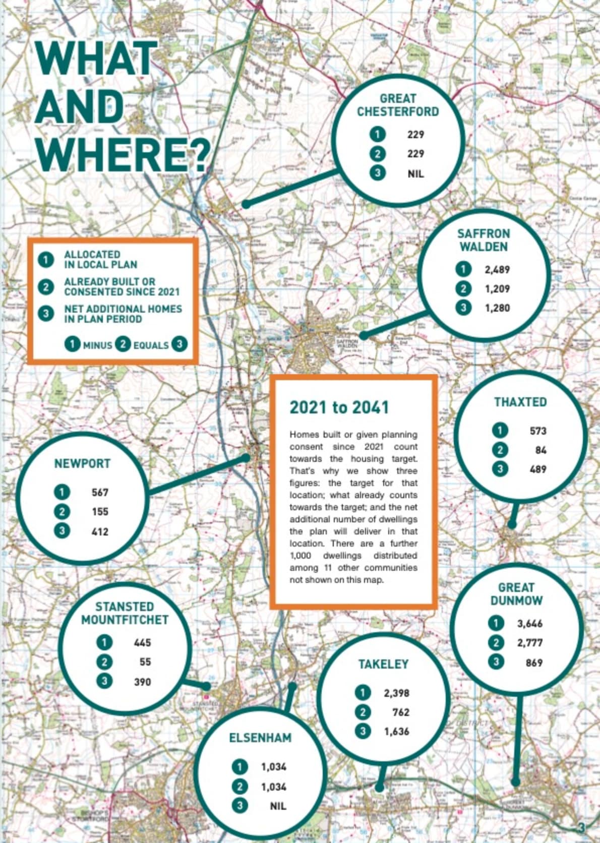
The new plan makes provision for 6,076 additional homes to be delivered over the plan period 2021 to 2041 after allowing for those already built or given planning consent since 2021. The main states are shown in the map below.
The approach has been belt and braces, and single-mindedly intent on meeting deadlines to get a plan in place. Once done, the district will have the relative luxury of fine tuning and looking to the future without constant attack by developers.
Local Plans must be reviewed at five-yearly intervals to ensure development is keeping pace with needs. While new towns do not feature in the short term it is possible, even likely, that a major new community will be needed at some point in the future to keep pace with regional population growth and local expansion of employment.
WHAT IT MEANS FOR OUR WARD
Rather unexpectedly, Great Chesterford gets no new housing allocation beyond what has already been built since 2021 or consented and awaiting construction (notably the 111 houses on the east side of London Road). Given the very rural nature of the ward there is little proposed development elsewhere in the ward.
However there is no room for complacency. Like so much of the district we have an infrastructure deficit created by what has been built over the past 15 years. We will need to fight our corner to get this remedied.
POLICIES WE ARE PUSHING
1. Rebalancing of house sizes and tenure. The evidence is stark: we need more smaller homes, greater affordability, houses for key workers and greater allocation of social housing.
2. A means by which communities can restore the infrastructure deficit left by earlier housing development. This is being addressed by the adoption of Community Infrastructure Levy (CIL), which will allow the community to specify what is needed and not be limited by the narrow provisions of the section 106 process.
3. Protection of river valleys as green corridors and an opportunity to achieve significant nature restoration by establishing buffer zones of sufficient distance between rivers and development to make a meaningful contribution to sustaining wildlife and providing recreational nature trails. There is also a focus on chalk streams as a rare habitat and the need to combat pollution of rivers.
THE PLAN TIMETABLE
• REG18 NOVEMBER–DECEMBER 2023
A period of public consultation on the “preferred options” contained in the draft. It is fully expected there will be changes to the plan before it goes to Reg19.
• REG19 NOVEMBER 2024
Public consultation on the “submission draft” i.e. what the council intends to submit to the Planning Inspectorate.
• SUBMISSION MAY 2025
The Plan along with all the consultation responses received at Reg19 are sent to the Planning Inspectorate with the expectation that the public examination will happen towards the end of 2024 or early 2025.
• ADOPTION MARCH 2026
Planning Inspectors almost always require modifications and it will take time to incorporate these before publishing the finished plan. March 2026 is an expected date when The Plan will come into full force.